Plate tectonics synthesis
A unified explanation of moving continents, ocean floors, earthquakes and mountain building.
- When
- 1960s
- Where
- Global Earth science
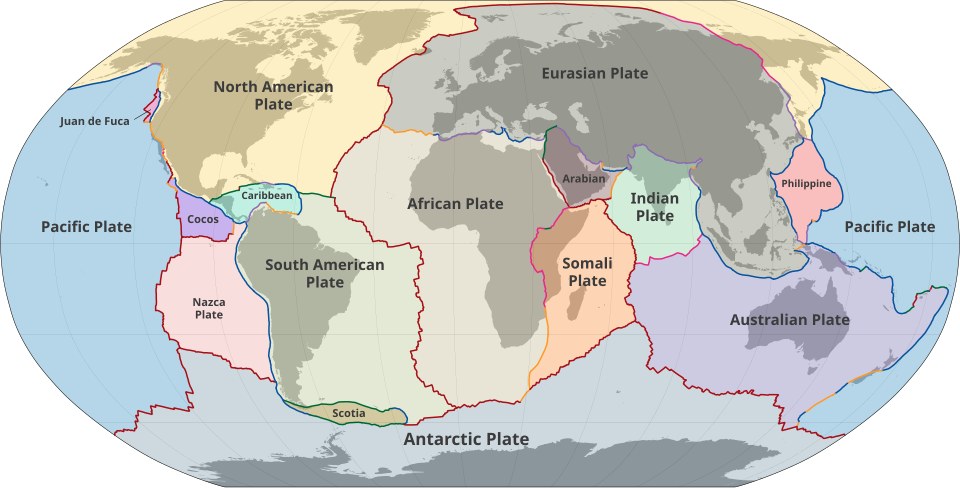
A unified explanation of moving continents, ocean floors, earthquakes and mountain building. Alfred Wegener had argued that continents moved, drawing on geological and fossil similarities. Many geologists rejected the idea because the proposed mechanisms were inadequate.
Background
Continental drift lacked an accepted mechanism
Alfred Wegener had argued that continents moved, drawing on geological and fossil similarities. Many geologists rejected the idea because the proposed mechanisms were inadequate. Later exploration of the ocean floor supplied evidence that could not be understood by treating continents and ocean basins as permanently fixed.[1]
What happened
- 1950s–1960s
The seabed provides a record
Mapping revealed mid-ocean ridges and deep trenches. Magnetic patterns in oceanic rocks recorded reversals in Earth's magnetic field, forming symmetrical stripes around ridges. These observations supported seafloor spreading: new crust formed and moved away while older material was consumed elsewhere.[1]
- 1960s
Moving plates connect the evidence
Researchers combined spreading, subduction, transform faults and earthquake distributions into a model of rigid lithospheric plates. Their boundaries explained why seismic and volcanic activity clustered in particular belts. The synthesis joined previously separate observations into a framework capable of making further predictions.[1]
Impact & evidence
Movement could be tested
Plate tectonics explained many large-scale features without requiring every place to behave identically. It also made the history of oceans and continents reconstructable. The model did not eliminate uncertainty about deep-Earth processes or establish exactly when modern-style tectonics began.[2]
Aftermath & legacy
A continuing scientific framework
Satellite measurements later allowed plate motions to be observed directly at rates of centimetres per year. The theory informs understanding of natural hazards, resources and Earth's long history. It explains where hazards arise, but does not provide precise predictions of when an individual earthquake will occur.[1]
Sources & image credits (2)
M.Bitton · CC BY-SA 3.0 (source record). Resized for display. Image source ↗